Virginia boasts a full quarter of the 2,135-mile Appalachian Trail (or AT), around 550 miles of hiking glory. The AT in Virginia features hikes leading to overlooks, waterfalls and wildernesses, as well as scenic, cultural and historical sites, even a trail town.
As the AT courses through Virginia’s Appalachian Mountains it travels an incredibly scenic land, a place where peaks tower thousands of feet above fertile valleys, where crashing cascades plunge into deep forests, where brawling rivers cut deep gorges through majestic highlands. Virginia’s section of the AT leads through a biological wonderment, experiencing elevation changes in excess of 4,000 feet that create ecotones replicating flora and fauna stretching from Georgia to New England.
The AT primarily wanders through Virginia’s Jefferson and Washington National Forests, collectively avail millions of acres of untamed forests, rich with flora and fauna. Then there are Virginia’s national parks the AT explores –Shenandoah National Park and the Blue Ridge Parkway. These preserves were set aside for a reason and avail more opportunities to experience the best of the Appalachian Trail.
Try these 10 rewarding hikes using the AT and its connecting paths in Virginia.
Damascus and Beyond

Length: 5.9-mile loop
Outstanding Features: Appalachian Trail town, streams, views
Trailhead GPS Coordinates: 36.63377, -81.79137
This fun and unusual AT hike incorporates the trail town of Damascus with adjacent Jefferson National Forest trails. Leave Damascus Town Park on the Virginia Creeper Trail. Along the way, you will see Damascus and the streams that flow through it. Leave the Creeper Trail for the Appalachian Trail. Take America’s most famous footpath up through wooded ridges. Pass a rewarding view of adjacent mountains. Meet the Iron Mountain Trail. Dip into a hollow and return to Damascus, rejoining the AT as it parades directly through downtown.
Know Before You Go: Bring your wallet to stop for treats while hiking the AT through Damascus!
Nearby Attractions:
- Mount Rogers Outfitters
- Virginia Creeper Trail
- Southwest Virginia Cultural Center & Marketplace
- Barter Theatre
Mount Rogers High Country
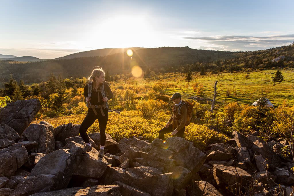
Photo Credit: Kyle LaFerriere, @laferriere.photography
Length: 2-10 miles, there-and-back or loop
Outstanding Features: Wild ponies, designated wilderness, rock outcrops
Trailhead GPS Coordinates: 36.62124, -81.48448
From Grayson Highlands State Park, join the AT as it rambles over Virginia’s rooftop, where open fields provide extensive panoramas of surrounding stone monoliths and rare spruce-fir forests. Visit the area’s famed wild ponies. Pass through Little Wilson Creek Wilderness. Explore a mosaic of environments en route to Pine Mountain. Ramble atop a mile high ridge. Rejoin the AT as it traverses rocky and open Wilburn Ridge.
Know Before You Go: This hike wanders in the Old Dominion’s loftiest lands. Be prepared for cool, foggy and potentially inclement weather.
Nearby Attractions:
- Grayson Highlands State Park camping
- New River Trail bicycling
- Rex Theater
- New River Outdoor Adventures
Chestnut Knob
Length: 9.2-mile there-and-back
Outstanding Features: Historic stone ranger cabin, Burkes Garden, open meadows
Trailhead GPS Coordinates: 36.63377, -81.79137
Experience solitude and superlative scenery on this trek. Take the Appalachian Trail past open meadows with breathtaking vistas to reach an old stone fire warden’s cabin atop Chestnut Knob. From this point, you can gaze upon Burkes Garden, one of Virginia's most lovely rural farmlands.
Know Before You Go: The hike goes over miles of open meadows. Watch for wooden post designating the AT through these fields.
Nearby Attractions:
McAfee Knob
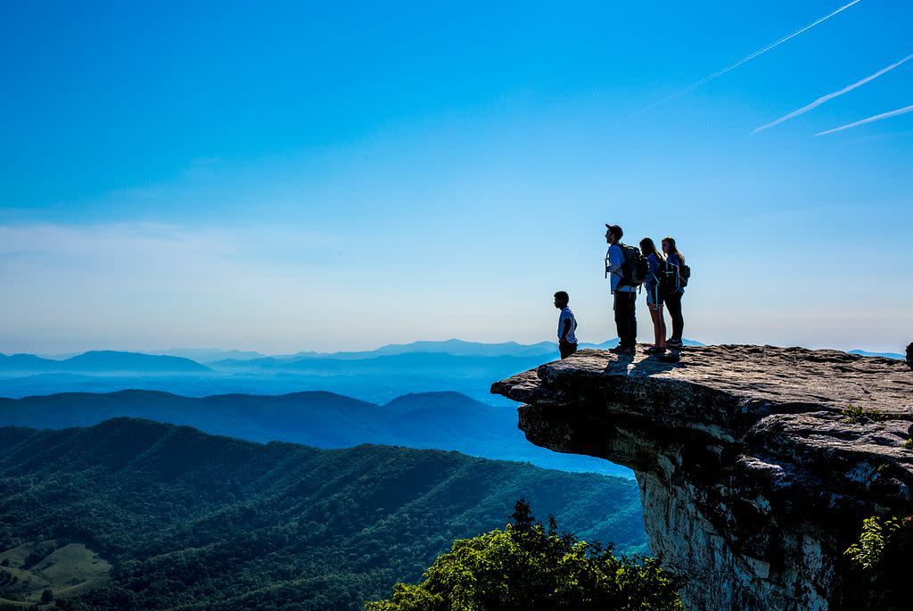
Photo Credit: Nate Dennison
Length: 7.8-mile there-and-back
Outstanding Features: Most photographed spot on AT
Trailhead GPS Coordinates: 37.38036, -80.0893
This busy hike deserves its popularity. McAfee Knob -- arguably the icon of Appalachian Trail in Virginia -- is not only great for snapping pictures of hikers standing atop its overhang, the views from the outcrop are far reaching. Start at the busy VA 311 trailhead and trace the AT northbound along Catawba Mountain. The moderate hike skirts past two trail shelters, then works up the slope of McAfee Knob. Open onto a long brow of overhanging rock where a mass of mountainlands extend to the horizon. An alternate return route is possible via a fire road.
Know Before You Go: This must-do hike is busy. Consider undertaking the hike early in the morning or late in the afternoon, and during the week.
Nearby Attractions:
- Paddle Craig Creek
- Walk the Hanging Rock Battlefield Trail
- Mill Mountain in Roanoke
- Poor Mountain Natural Area Preserve
Angels Rest
Length: 5.0-mile there and back
Outstanding Features: Incredible vistas, challenging climb
Trailhead GPS Coordinates: 37.32991, -80.76299
This AT trek climbs the northeast shoulder of Pearis Mountain to three rewarding views. Start near the town of Pearisburg, then trace a series of switchbacks up a thickly wooded ridge. Once on the crest, enter a boulder garden to emerge at Angels Rest and its eye-popping view of the New River Valley. From there, head south along Pearis Mountain, passing a lesser view before reaching Wilburn Valley Overlook, presenting bucolic Virginia countryside set between long ridges.
Know Before You Go: Bring your mojo along -- the ascent from Pearisburg to the top of Pearis Mountain is steady, but do-able.
Nearby Attractions:
- Paddle, raft or tube the New River
- Visit Giles County Historical Society
- Hike at Cascade Falls
- Tangent Outfitters
Kelly Knob
Length: 4.0-mile there and back
Outstanding Features: Solitude, high country, view
Trailhead GPS Coordinates: 37.3727, -80.44603
This fairly easy hike to a view offers solitude aplenty, sometimes hard to find on the Appalachian Trail. Start your hike at the historic village of Newport, north of Blacksburg, then make a quick but short climb to the crest of Johns Creek Mountain. From there, it is easy walk to Kelly Knob, where a spur leads to an outcrop and views of the New River Valley and adjoining mountains.
Know Before You Go: The stone base of the outcrop atop Kelly Knob is fissured, watch for the cracks as you hopscotch for views from the vista point.
Nearby Attractions:
- Paddle, raft or tube the New River
- Tour Blacksburg
- Sinking Creek Covered Bridge
- Mountain bike at Pandapas Pond
Blackrock Summit
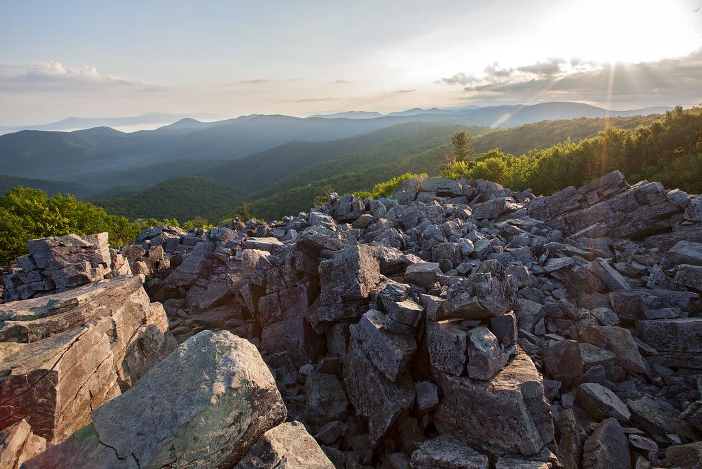
Length: 1.1-mile loop
Outstanding Features: Family-friendly, wide-ranging panoramas from boulder jumble
Trailhead GPS Coordinates: 38.223, -78.73331
This family-friendly, geologically fascinating loop has fun written all over it. Make an easy walk from Shenandoah National Park’s Skyline Drive to an incredible rock jumble on the Appalachian Trail. Views extend for miles in multiple directions from the summit of boulder-strewn Blackrock. After gaining views from several spots, reenter woods, cruising back to the trailhead. Elevation changes are minimal, relaxation spots are ample and boulder scrambling is an amusing option.
Know Before You Go: Hikers can increase this walk, finding solitude and more panoramas from little-visited Furnace Mountain by taking the Trayfoot Mountain Trail, then Furnace Mountain Trail for a 6.8-mile out-and-back hike from the Blackrock trailhead.
Nearby Attractions:
- Skyline Drive
- Camp at Loft Mountain
- Grand Caverns in Grottoes
- Seven Arrows Brewing Company in Waynesboro
Ottie Powell Memorial
Length: 7.8-mile there-and-back
Outstanding Features: Views from Bluff Mountain
Trailhead GPS Coordinates: 37.67793, -79.33386
Trace the Appalachian Trail up to Bluff Mountain, the site of a fire tower that still presents wide vistas. There lies the memorial to little Ottie Powell, lost a century back. His body was found atop Bluff Mountain and his story became legend. Even now, Ottie’s ghost is said to haunt nearby Punchbowl Mountain trail shelter – which you will visit enroute to Bluff Mountain.
Know Before You Go: Bring your ghost-buster kit with you, especially if camping overnight in the Punchbowl Mountain trail shelter.
Nearby Attractions:
The Priest Wilderness
Length: 3.6-mile there-and-back
Outstanding Features: Views from The Priest, federally designated wilderness
Trailhead GPS Coordinates: 37.83003, -79.08279
The hike to The Priest travels through The Priest Wilderness, a 5,963-acre reserve set aside in the year 2000. The wilderness encompasses the highest part of The Priest Mountain, as well as springs and streams spilling off it. Soak in spectacular views of the Tye River Valley and visit a trail shelter on the way.
Know Before You Go: From this same trailhead, you can also hike to Crabtree Falls, Virginia’s highest waterfall and arguably the highest cataract in the East.
Nearby Attractions:
Lewis Spring Falls
Length: 3.4-mile loop
Outstanding Features: Family-friendly, wide-ranging panoramas from boulder jumble
Trailhead GPS Coordinates: 38.223, -78.73331
This popular, high country loop takes place in the Big Meadows area of Shenandoah National Park. Hike northbound on the Appalachian Trail, climbing to view-laden and geologically rich Blackrock (a different peak than Blackrock of the South District of the park). From there, the hike passes more captivating rock features, then joins the Lewis Falls Trail, leading to 81-foot Lewis Falls, a loud and dramatic cataract, complemented with its own views near and far. Loop back to the trailhead.
Know Before You Go: The greater Big Meadows area of Shenandoah National Park is just north of this trailhead. Here, you can go to the park visitor center, overnight at a lodge, camp in a campground, take guided ranger tours or head to a camp store.
Nearby Attractions: